Drone Photos for Beachfront Rentals: What the Aerial Must Prove
Tips
6 Min Read
A beach rental aerial should show distance to the sand, orientation, pool, parking and neighbours. Here is how we plan drone shots for Pinellas beach homes.

More Articles




A beach rental aerial earns its place when it answers five questions in one frame: how far the sand is, which way the house faces, what the pool and parking look like, and who the neighbours are. Our packages all include aerial drone photos, flown by FAA Part 107 certified pilots, so the shot is planned, not improvised.
Start with distance to the beach
“Steps from the sand” is the most overused phrase in Gulf Coast listings. Guests have learned to distrust it. An aerial that shows the real path from the door to the water ends the argument. For a beachfront unit that means the shoreline must be in frame with the building. For a walk-to-beach house, include the street, the beach access and the shoreline, even if that means flying a little higher so everything fits.
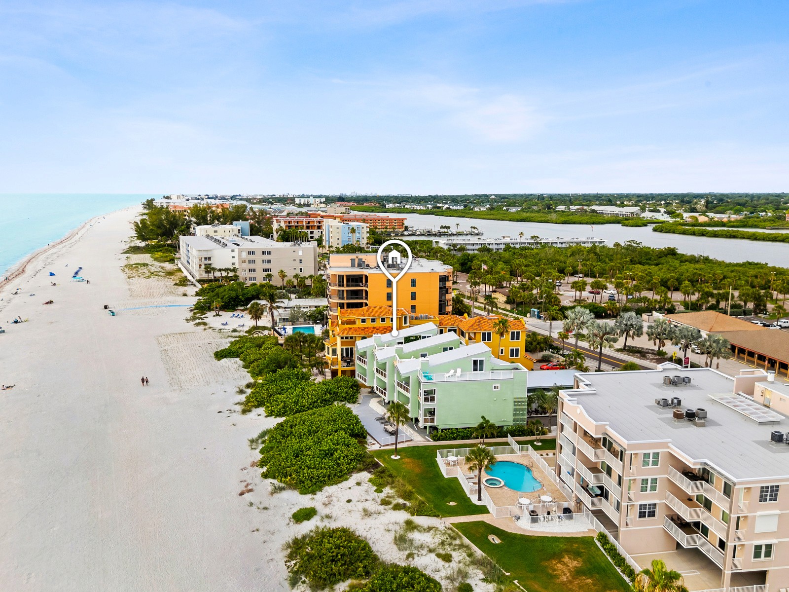
The Indian Shores home in the photo above is a good example. In one frame you see the beach to the west, the building footprint, the pool area, the roadside parking and the bay-side water behind the island. A guest can work out the layout without reading a word. You can see the whole job on the Indian Shores Airbnb project page.
Orientation: say where the sun goes
On the Pinellas barrier islands the Gulf is to the west, so beach-facing balconies get sunset views and late afternoon glare. A guest booking a week in July wants to know whether the deck is shaded at 4 PM. An aerial taken from the right height and angle tells them. It also lets you describe the unit honestly: sunrise side or sunset side, street side or water side. We shoot the drone set at a time of day that suits the orientation, which is one reason we ask for the street address before we book the slot.
Pool, deck and parking
These are the amenities people screenshot and send to the group chat. A shared condo pool should be photographed from above, with loungers visible, so guests see its real size. A private pool needs the fence, the deck and the screen enclosure (if there is one) in frame. Parking is the one many hosts forget: a top-down or high-angle shot of the driveway or the lot lets guests count spaces. If street parking is the reality, show the street.
Neighbours and surroundings
This is the part hosts worry about, and it is also the part that prevents bad reviews. A drone frame will show the next building, the lot next door and whether the view is open sand or another balcony. Do not hide it. A guest who sees a neighbouring condo tower before booking will not be surprised later, and that surprise is what turns into a three-star review. We frame to be accurate, and we edit for colour and clarity, not to remove buildings.
How many aerial photos is enough
Most beach rentals need three to six aerial frames: one wide for location, one at the beach side, one of the pool and deck, one of parking or access, and one showing the surrounding streets or water. Our aerial photos and video service adds extra frames as an option: 10 drone photos are $125, drone video up to one minute is $150, and a package of up to 12 drone photos plus video is $250. Those add-on prices apply when you want more than your package includes.
Rules that affect when and how we fly
Commercial drone flights in the U.S. fall under FAA Part 107. Among other things, flights are limited to 400 feet above ground level and the pilot must keep the aircraft in visual line of sight. Airspace near some airports is controlled, and flying there requires authorization from the FAA before takeoff (the FAA’s LAANC system handles many of these requests). Our pilots handle that process. Beach crowds matter too: we avoid flying over people, so we pick the hours that work for both the light and the beach.
Local flight rules for specific parks or beaches can be different from FAA rules, so we check them before the shoot instead of assuming. Check your own city and county short-term-rental rules separately.
Area notes: Indian Rocks Beach, Indian Shores, Clearwater Beach
All three are on the Pinellas Gulf coast. Clearwater Beach is the northernmost of the three and is reached by causeway from Clearwater, Indian Rocks Beach lies south of it, and Indian Shores is just south of Indian Rocks Beach. Each sits on a narrow island, which means a single drone frame can often show both Gulf and bay water. See our pages for Indian Rocks Beach, Indian Shores and Clearwater Beach.
Questions we get about aerial photos for beach rentals
Is a drone included in the price?
Aerial drone photos are included in all our packages (Basic from $190, Standard from $325, Premium from $495, Deluxe from $750). Extra drone photos and drone video can be added. Standalone Airbnb photos start at $250, and you can ask us to add aerials.
Are your drone pilots licensed?
Our drone work is done by FAA Part 107 certified pilots. That is the FAA’s certification for commercial small-drone operations.
Can you fly in any weather?
No. High wind and rain stop a flight, and we reschedule when that happens. We would rather move the aerial set than hand you a shaky, grey frame.
What should the aerial show if my rental is not on the beach?
Show the route. Include the house, the street, the beach access point and the shoreline in one wide frame, so the real walking distance is clear to guests.
How quickly do I get the aerials?
Photos come back with a 24-hour turnaround.
If you have a beach rental and want the aerial planned properly, ask us at our contact page. You can also look over pricing first.


Similar Topic